Copyright © 2012-2023 WWRCo-op. All rights reserved.
|
Glossary of Terms
|
- WWR: Westwood Ranch
- WWROA: Westwood Ranches Owner’s Road Maintenance Association. The WWROA manages road maintenance for all ‘Exhibit-E’ roads on the ranch. Membership for WWR owners of lot #s 547-1112 is mandatory.
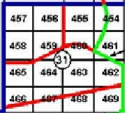
- Exhibit-E Roads: GREEN roads on the New Color Coded Ranch Map
- Legal Access Roads: Legal Access Roads are depicted on the Legal Access Map. Legal access roads cannot be gated, or otherwise obstruct
- WWR Co-op: By contract deed, WWR lot #s 1-545 owners are responsible for their own road maintenance, at their own expense. The alternative, is to partner with the Co-op. The WWR Co-op is managed by a group of Co-op owner/contributor volunteers who coordinate road maintenance [for Co-op lot owners] for the ‘non-Exhibit-E Legal Access Roads’ on WWR. The Co-op’s aim & purpose is to facilitate the road maintenance, & to help distribute road maintenance costs among ‘the many’, ultimately reducing the cost to ‘the few’. The Co-op can only be effective if owners ‘co-operate’ by contributing.
- Co-op Lot Owners: WWR owners of lot #s 1-545.
- Co-op Contributor: A Co-op lot owner that contributes to road maintenance.
- Section [on Ranch Map]: The WWR map is divided into larger squares, somewhat resembling a checkerboard. Most squares, or ’sections’, are numbered in the middle, & generally contain sixteen, forty-acre lots (# of lots vary by section).
- Co-op roads: WWR is made up of roughly 146 sections (on checkerboard map). Of those 146 sections, 71 are State Land, 37 are Co-op, & 38 WWROA sections. The Co-op sections contain lot #s 1 - 545; the WWROA sections contain lot #s 547 - 1112. All GREEN roads on the Color Coded Ranch Map are maintained by the WWROA, including GREEN roads within the Co-op sections.
- MM: Mile Markers - Posted each mile along Ranch Rd (starting from gate), & on Six Shooter (starting from Ranch Rd & Six Shooter). MMs are depicted on the WWR Color Coded Ranch Map in Yellow, & Brown, respectively.
|